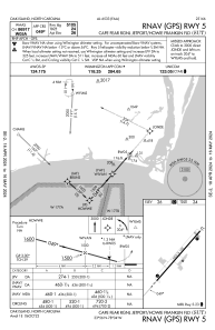
IAC chart of KSUT
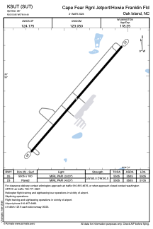
 ADC chart of KSUT
 Satellite view of KSUT
ADC chart of KSUT
Satellite view of KSUT
Sorry, we have no imagery here.
Sorry, we have no imagery here.
Sorry, we have no imagery here.
Sorry, we have no imagery here.
Sorry, we have no imagery here.
Sorry, we have no imagery here.


KSUT - Cape Fear Rgnl Jetport/Howie Franklin Fld
Located in Oak Island, United States
ICAO - SUT, IATA -
Data provided by AirmateGeneral information
Coordinates: N33°55'51" W78°4'24"
Elevation is 26 feet MSL.
Magnetic variation is -08° East View others Airports in North Carolina
Operational data
Special qualification required
Current time UTC:
Current local time:
Weather
METAR: KSUT 012309Z AUTO 10003KT 10SM CLR 19/15 A3006 RMK AO2
Communications frequencies: [VIEW]
Runways:
| RWY identifier | QFU | Length (ft) | Width (ft) | Surface | LDA (ft) |
| 05 | 41° | 5505 | 100 | ASPH | 5505 |
| 23 | 221° | 5505 | 100 | ASPH | 5105 |
Airport contact information
Address: Oak Island United States
Other aviation service providers
Flight schools

Satellite view of KSUT
Sorry, we have no imagery here.
Sorry, we have no imagery here.
Sorry, we have no imagery here.
Sorry, we have no imagery here.
Sorry, we have no imagery here.
Sorry, we have no imagery here.