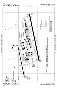


KSUS - Spirit Of St Louis
Located in St Louis, United States
ICAO - SUS, IATA -
Data provided by AirmateGeneral information
Coordinates: N38°39'44" W90°39'7"
Elevation is 463 feet MSL.
Magnetic variation is -01° East View others Airports in Missouri
Operational data
Special qualification required
Current time UTC:
Current local time:
Weather
METAR: KSUS 110554Z AUTO 22012G24KT 10SM CLR 17/M01 A2973 RMK AO2 SLP064 T01721011 10200 20122 402331022 58004
TAF: KSUS 110520Z 1106/1206 22006KT P6SM SKC WS020/25040KT FM111300 24007KT P6SM SKC FM111900 VRB05KT P6SM FEW250
Communications frequencies: [VIEW]
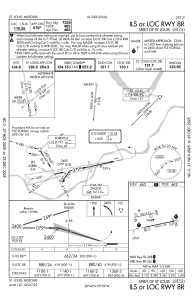
Runways:
| RWY identifier | QFU | Length (ft) | Width (ft) | Surface | LDA (ft) |
| 08L | 78° | 5000 | 75 | ASPH | 5000 |
| 26R | 258° | 5000 | 75 | ASPH | 5000 |
| 08R | 78° | 7485 | 150 | CONC | 7414 |
| 26L | 258° | 7485 | 150 | CONC | 7004 |
Airport contact information
Address: St Louis United States
