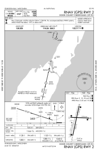
IAC chart of KSUE
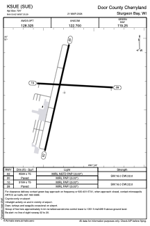
 ADC chart of KSUE
 Satellite view of KSUE
ADC chart of KSUE
Satellite view of KSUE
Sorry, we have no imagery here.
Sorry, we have no imagery here.
Sorry, we have no imagery here.
Sorry, we have no imagery here.
Sorry, we have no imagery here.
Sorry, we have no imagery here.


KSUE - Door County Cherryland
Located in Sturgeon Bay, United States
ICAO - SUE, IATA -
Data provided by AirmateGeneral information
Coordinates: N44°50'37" W87°25'18"
Elevation is 724 feet MSL.
Magnetic variation is -03° East View others Airports in Wisconsin
Operational data
Special qualification required
Current time UTC:
Current local time:
Weather
METAR: KSUE 280457Z AUTO 00000KT 10SM CLR 16/04 A3017 RMK AO2 SLP215 T01560039
Communications frequencies: [VIEW]
Runways:
| RWY identifier | QFU | Length (ft) | Width (ft) | Surface | LDA (ft) |
| 02 | 13° | 4599 | 75 | ASPH | |
| 20 | 193° | 4599 | 75 | ASPH | |
| 10 | 93° | 3199 | 75 | ASPH | |
| 28 | 273° | 3199 | 75 | ASPH |
Airport contact information
Address: Sturgeon Bay United States
Satellite view of KSUE
Sorry, we have no imagery here.
Sorry, we have no imagery here.
Sorry, we have no imagery here.
Sorry, we have no imagery here.
Sorry, we have no imagery here.
Sorry, we have no imagery here.