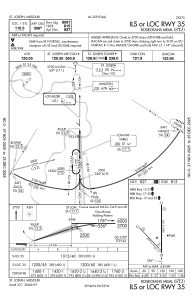
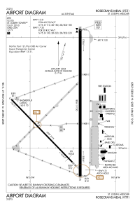


KSTJ - Rosecrans Meml
Located in St Joseph, United States
ICAO - STJ, IATA -
Data provided by AirmateGeneral information
Coordinates: N39°46'19" W94°54'35"
Elevation is 826 feet MSL.
Magnetic variation is 04° East View others Airports in Missouri
Operational data
Special qualification required
Current time UTC:
Current local time:
Weather
METAR: KSTJ 110553Z AUTO 21012KT 10SM CLR A2964 RMK AO2 SLPNO 57007
TAF: KSTJ 110520Z 1106/1206 20010KT P6SM SKC WS020/23050KT FM111300 03012KT P6SM SKC FM112300 07006KT P6SM FEW250
Communications frequencies: [VIEW]
Runways:
| RWY identifier | QFU | Length (ft) | Width (ft) | Surface | LDA (ft) |
| 13 | 136° | 4797 | 75 | CONC | 4797 |
| 31 | 316° | 4797 | 75 | CONC | 4797 |
| 17 | 180° | 8061 | 150 | CONC | 8061 |
| 35 | 0° | 8061 | 150 | CONC | 8061 |
Airport contact information
Address: St Joseph United States