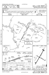
IAC chart of KSTE
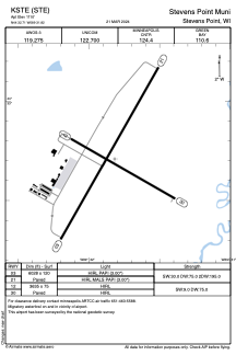
 ADC chart of KSTE
 Satellite view of KSTE
ADC chart of KSTE
Satellite view of KSTE
Sorry, we have no imagery here.
Sorry, we have no imagery here.
Sorry, we have no imagery here.
Sorry, we have no imagery here.
Sorry, we have no imagery here.
Sorry, we have no imagery here.


KSTE - Stevens Point Muni
Located in Stevens Point, United States
ICAO - STE, IATA -
Data provided by AirmateGeneral information
Coordinates: N44°32'42" W89°31'49"
Elevation is 1110 feet MSL.
Magnetic variation is -01° East View others Airports in Wisconsin
Operational data
Special qualification required
Current time UTC:
Current local time:
Weather
METAR: KSTE 302155Z AUTO 29006G15KT 10SM SCT120 24/10 A2974 RMK AO2 T02420100
Communications frequencies: [VIEW]
Runways:
| RWY identifier | QFU | Length (ft) | Width (ft) | Surface | LDA (ft) |
| 03 | 30° | 6028 | 120 | ASPH | |
| 21 | 210° | 6028 | 120 | ASPH | |
| 12 | 120° | 3635 | 75 | ASPH | |
| 30 | 300° | 3635 | 75 | ASPH |
Airport contact information
Address: Stevens Point United States
Other aviation service providers
Flight schools

Satellite view of KSTE
Sorry, we have no imagery here.
Sorry, we have no imagery here.
Sorry, we have no imagery here.
Sorry, we have no imagery here.
Sorry, we have no imagery here.
Sorry, we have no imagery here.