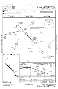
IAC chart of KSSQ
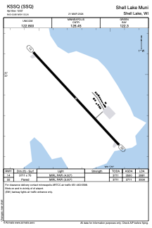
 ADC chart of KSSQ
 Satellite view of KSSQ
ADC chart of KSSQ
Satellite view of KSSQ
Sorry, we have no imagery here.
Sorry, we have no imagery here.
Sorry, we have no imagery here.
Sorry, we have no imagery here.
Sorry, we have no imagery here.
Sorry, we have no imagery here.


KSSQ - Shell Lake Muni
Located in Shell Lake, United States
ICAO - SSQ, IATA -
Data provided by AirmateGeneral information
Coordinates: N45°43'53" W91°55'14"
Elevation is 1233 feet MSL.
Magnetic variation is 01° East View others Airports in Wisconsin
Operational data
Special qualification required
Current time UTC:
Current local time:
Weather at : KUBE - Cumberland Muni ( 25 km )
METAR: KUBE 281555Z AUTO 01005KT 10SM SCT070 SCT080 16/10 A3018 RMK AO2
Communications frequencies: [VIEW]
Runways:
| RWY identifier | QFU | Length (ft) | Width (ft) | Surface | LDA (ft) |
| 14 | 137° | 3711 | 75 | ASPH | 2881 |
| 32 | 317° | 3711 | 75 | ASPH | 3500 |
Airport contact information
Address: Shell Lake United States
Satellite view of KSSQ
Sorry, we have no imagery here.
Sorry, we have no imagery here.
Sorry, we have no imagery here.
Sorry, we have no imagery here.
Sorry, we have no imagery here.
Sorry, we have no imagery here.