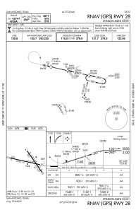
IAC chart of KSSF
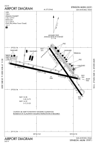
 ADC chart of KSSF
 Satellite view of KSSF
ADC chart of KSSF
Satellite view of KSSF
Sorry, we have no imagery here.
Sorry, we have no imagery here.
Sorry, we have no imagery here.
Sorry, we have no imagery here.
Sorry, we have no imagery here.
Sorry, we have no imagery here.


KSSF - Stinson Muni
Located in San Antonio, United States
ICAO - SSF, IATA -
Data provided by AirmateGeneral information
Coordinates: N29°20'13" W98°28'16"
Elevation is 577 feet MSL.
Magnetic variation is 08° East View others Airports in Texas
Operational data
Special qualification required
Current time UTC:
Current local time:
Weather
METAR: KSSF 020553Z AUTO 14012G19KT 10SM BKN016 OVC021 24/21 A2955 RMK AO2 SLP997 T02390206 10289 20239 403220194 58003
TAF: KSSF 020535Z 0206/0306 14010KT P6SM OVC019 FM021200 15009KT P6SM OVC009 FM021400 16007KT P6SM OVC019 FM021700 04008KT 6SM HZ OVC025 FM021800 06006KT P6SM BKN035 FM030400 12012KT P6SM OVC015
Communications frequencies: [VIEW]
Runways:
| RWY identifier | QFU | Length (ft) | Width (ft) | Surface | LDA (ft) |
| 09 | 103° | 5000 | 100 | ASPH | 4550 |
| 27 | 283° | 5000 | 100 | ASPH | 4677 |
| 14 | 145° | 4128 | 100 | ASPH | 3297 |
| 32 | 325° | 4128 | 100 | ASPH | 3530 |
Airport contact information
Address: San Antonio United States
Other aviation service providers
Flight schools

Satellite view of KSSF
Sorry, we have no imagery here.
Sorry, we have no imagery here.
Sorry, we have no imagery here.
Sorry, we have no imagery here.
Sorry, we have no imagery here.
Sorry, we have no imagery here.