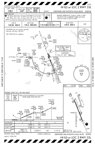
IAC chart of KSPS
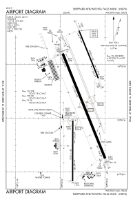
 ADC chart of KSPS
 Satellite view of KSPS
ADC chart of KSPS
Satellite view of KSPS
Sorry, we have no imagery here.
Sorry, we have no imagery here.
Sorry, we have no imagery here.
Sorry, we have no imagery here.
Sorry, we have no imagery here.
Sorry, we have no imagery here.


KSPS - Sheppard Afb/Wichita Falls Muni
Located in Wichita Falls, United States
ICAO - SPS, IATA - SPS
Data provided by AirmateGeneral information
Coordinates: N33°59'20" W98°29'31"
Elevation is 1019 feet MSL.
Magnetic variation is 05° East View others Airports in Texas
Operational data
Special qualification required
Current time UTC:
Current local time:
Weather
METAR: KSPS 011852Z 18020G33KT 10SM CLR 28/16 A2954 RMK AO2 PK WND 17036/1801 SLP993 T02830161
TAF: KSPS 011737Z 0118/0218 18020G30KT P6SM SCT030 BKN035 FM012300 17025G30KT P6SM VCTS SCT025CB TEMPO 0123/0202 2SM +TSRA BKN025CB FM020800 18020KT P6SM BKN015 BKN250 PROB30 0209/0212 6SM -SHRA FM021200 23015G20KT P6SM BKN250
Communications frequencies: [VIEW]
Runways:
| RWY identifier | QFU | Length (ft) | Width (ft) | Surface | LDA (ft) |
| 15C | 158° | 10003 | 150 | OTHER | |
| 33C | 338° | 10003 | 150 | OTHER | |
| 15L | 158° | 6000 | 150 | OTHER | |
| 33R | 338° | 6000 | 150 | OTHER | |
| 15R | 158° | 13100 | 300 | CONC | |
| 33L | 338° | 13100 | 300 | CONC | |
| 18 | 180° | 7021 | 150 | ASPH | |
| 36 | 0° | 7021 | 150 | ASPH |
Airport contact information
Address: Wichita Falls United States
Satellite view of KSPS
Sorry, we have no imagery here.
Sorry, we have no imagery here.
Sorry, we have no imagery here.
Sorry, we have no imagery here.
Sorry, we have no imagery here.
Sorry, we have no imagery here.