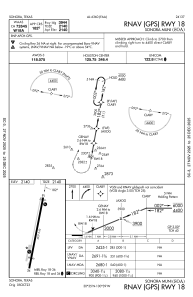
IAC chart of KSOA
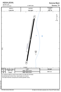
 ADC chart of KSOA
 Satellite view of KSOA
ADC chart of KSOA
Satellite view of KSOA
Sorry, we have no imagery here.
Sorry, we have no imagery here.
Sorry, we have no imagery here.
Sorry, we have no imagery here.
Sorry, we have no imagery here.
Sorry, we have no imagery here.


KSOA - Sonora Muni
Located in Sonora, United States
ICAO - SOA, IATA -
Data provided by AirmateGeneral information
Coordinates: N30°35'8" W100°38'55"
Elevation is 2139 feet MSL.
Magnetic variation is 08° East View others Airports in Texas
Operational data
Special qualification required
Current time UTC:
Current local time:
Weather
METAR: KSOA 020835Z AUTO 17013KT 7SM BKN018 BKN023 24/20 A2956 RMK AO2
TAF: KSOA 020536Z 0206/0306 16016G24KT P6SM BKN025 FM021100 24008KT P6SM SCT015 BKN250 FM021400 01007KT P6SM BKN250 FM022200 12010KT P6SM SCT050
Communications frequencies: [VIEW]
Runways:
| RWY identifier | QFU | Length (ft) | Width (ft) | Surface | LDA (ft) |
| 18 | 190° | 4037 | 60 | ASPH | |
| 36 | 10° | 4037 | 60 | ASPH |
Airport contact information
Address: Sonora United States
Satellite view of KSOA
Sorry, we have no imagery here.
Sorry, we have no imagery here.
Sorry, we have no imagery here.
Sorry, we have no imagery here.
Sorry, we have no imagery here.
Sorry, we have no imagery here.