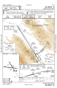
IAC chart of KSNS
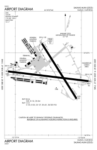
 ADC chart of KSNS
 Satellite view of KSNS
ADC chart of KSNS
Satellite view of KSNS
Sorry, we have no imagery here.
Sorry, we have no imagery here.
Sorry, we have no imagery here.
Sorry, we have no imagery here.
Sorry, we have no imagery here.
Sorry, we have no imagery here.


KSNS - Salinas Muni
Located in Salinas, United States
ICAO - SNS, IATA -
Data provided by AirmateGeneral information
Coordinates: N36°39'45" W121°36'26"
Elevation is 84 feet MSL.
Magnetic variation is 13° East View others Airports in California
Operational data
Special qualification required
Current time UTC:
Current local time:
Weather
METAR: KSNS 050853Z AUTO 17003KT 10SM CLR 08/06 A3025 RMK AO2 SLP251 T00830061 58000
TAF: KSNS 050520Z 0506/0606 35006KT P6SM FEW250 FM051200 12008KT P6SM SCT250 FM052000 30012KT P6SM SKC FM060300 35006KT P6SM SKC
Communications frequencies: [VIEW]
Runways:
| RWY identifier | QFU | Length (ft) | Width (ft) | Surface | LDA (ft) |
| 08 | 97° | 6004 | 150 | ASPH | |
| 26 | 277° | 6004 | 150 | ASPH | |
| 13 | 148° | 4825 | 150 | ASPH | |
| 31 | 328° | 4825 | 150 | ASPH | |
| H1 | 0° | 0 | 0 | UNK |
Airport contact information
Address: Salinas United States
Other aviation service providers
Flight schools

Aerodynamic Aviation - Salinas
Aerodynamic Aviation - Salinas
info@aerodynamicaviation.com+1(831)240-0800
Satellite view of KSNS
Sorry, we have no imagery here.
Sorry, we have no imagery here.
Sorry, we have no imagery here.
Sorry, we have no imagery here.
Sorry, we have no imagery here.
Sorry, we have no imagery here.