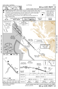
IAC chart of KSMX
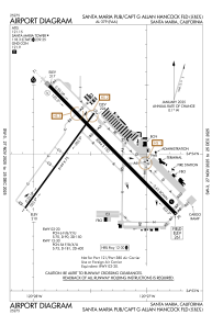
 ADC chart of KSMX
 Satellite view of KSMX
ADC chart of KSMX
Satellite view of KSMX
Sorry, we have no imagery here.
Sorry, we have no imagery here.
Sorry, we have no imagery here.
Sorry, we have no imagery here.
Sorry, we have no imagery here.
Sorry, we have no imagery here.


KSMX - Santa Maria Pub/Capt G Allan Hancock Fld
Located in Santa Maria, United States
ICAO - SMX, IATA - SMX
Data provided by AirmateGeneral information
Coordinates: N34°53'60" W120°27'29"
Elevation is 261 feet MSL.
Magnetic variation is 14° East View others Airports in California
Operational data
Special qualification required
Current time UTC:
Current local time:
Weather
METAR: KSMX 050851Z AUTO 25003KT 10SM CLR 07/06 A3021 RMK AO2 SLP233 T00670056 58002
TAF: KSMX 050550Z 0506/0606 VRB03KT P6SM SCT250 FM052000 30010KT P6SM FEW250 FM060300 VRB03KT P6SM FEW250
Communications frequencies: [VIEW]
Runways:
| RWY identifier | QFU | Length (ft) | Width (ft) | Surface | LDA (ft) |
| 02 | 36° | 5199 | 75 | ASPH | 5199 |
| 20 | 216° | 5199 | 75 | ASPH | 5199 |
| 12 | 135° | 8004 | 150 | ASPH | 8004 |
| 30 | 315° | 8004 | 150 | ASPH | 8004 |
Airport contact information
Address: Santa Maria United States
Satellite view of KSMX
Sorry, we have no imagery here.
Sorry, we have no imagery here.
Sorry, we have no imagery here.
Sorry, we have no imagery here.
Sorry, we have no imagery here.
Sorry, we have no imagery here.