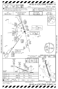
IAC chart of KSKF
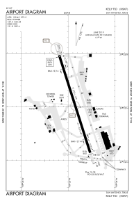
 ADC chart of KSKF
 Satellite view of KSKF
ADC chart of KSKF
Satellite view of KSKF
Sorry, we have no imagery here.
Sorry, we have no imagery here.
Sorry, we have no imagery here.
Sorry, we have no imagery here.
Sorry, we have no imagery here.
Sorry, we have no imagery here.


KSKF - Kelly Fld
Located in San Antonio, United States
ICAO - SKF, IATA - SKF
Data provided by AirmateGeneral information
Coordinates: N29°23'3" W98°34'52"
Elevation is 690 feet MSL.
Magnetic variation is 04° East View others Airports in Texas
Operational data
Special qualification required
Current time UTC:
Current local time:
Weather
METAR: KSKF 021400Z AUTO 14012KT 6SM HZ OVC018 24/21 A2952 RMK AO2 SLP989 $
TAF: TAF KSKF 021000Z 0210/0316 15011KT 9999 OVC016 QNH2950INS BECMG 0211/0212 15007KT 9000 BR SCT009 OVC014 QNH2951INS TEMPO 0212/0215 6000 -DZ BR BKN009 OVC014 BECMG 0215/0216 15006KT 9000 HZ BKN020 BKN250 QNH2955INS BECMG 0217/0218 06005KT 9999 NSW BKN030 BKN250 QNH2949INS BECMG 0221/0222 10009KT 9999 SCT040 BKN250 QNH2947INS BECMG 0302/0303 11011KT 9999 SCT017 BKN025 QNH2952INS BECMG 0304/0305 13013KT 9999 BKN014 OVC020 QNH2955INS BECMG 0310/0311 14006KT 8000 BR OVC010 QNH2956INS TEMPO 0311/0315 4000 -DZ BR OVC008 TX33/0222Z TN22/0213Z
Communications frequencies: [VIEW]
Runways:
| RWY identifier | QFU | Length (ft) | Width (ft) | Surface | LDA (ft) |
| 16 | 162° | 11550 | 150 | CONC | |
| 34 | 342° | 11550 | 150 | CONC |
Airport contact information
Address: San Antonio United States
Satellite view of KSKF
Sorry, we have no imagery here.
Sorry, we have no imagery here.
Sorry, we have no imagery here.
Sorry, we have no imagery here.
Sorry, we have no imagery here.
Sorry, we have no imagery here.