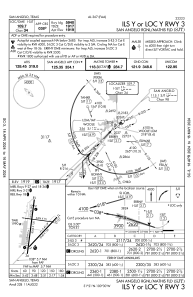
IAC chart of KSJT
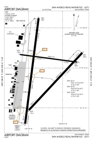
 ADC chart of KSJT
 Satellite view of KSJT
ADC chart of KSJT
Satellite view of KSJT
Sorry, we have no imagery here.
Sorry, we have no imagery here.
Sorry, we have no imagery here.
Sorry, we have no imagery here.
Sorry, we have no imagery here.
Sorry, we have no imagery here.


KSJT - San Angelo Rgnl/Mathis Fld
Located in San Angelo, United States
ICAO - SJT, IATA - SJT
Data provided by AirmateGeneral information
Coordinates: N31°21'28" W100°29'47"
Elevation is 1918 feet MSL.
Magnetic variation is 05° East View others Airports in Texas
Operational data
Special qualification required
Current time UTC:
Current local time:
Weather
METAR: KSJT 021251Z 33014KT 4SM HZ CLR 19/M01 A2962 RMK AO2 PK WND 33030/1200 WSHFT 1154 SLP007 T01891011
TAF: KSJT 021213Z 0212/0312 32020G30KT 4SM HZ FEW040 BKN100 FM021400 31010G18KT P6SM SCT250 FM022100 20008KT P6SM FEW250 FM030000 12010G18KT P6SM SCT250 FM030600 07008KT P6SM BKN050
Communications frequencies: [VIEW]
Runways:
| RWY identifier | QFU | Length (ft) | Width (ft) | Surface | LDA (ft) |
| 03 | 43° | 5940 | 150 | ASPH | 5940 |
| 21 | 223° | 5940 | 150 | ASPH | 5940 |
| 09 | 97° | 4406 | 75 | ASPH | 4406 |
| 27 | 277° | 4406 | 75 | ASPH | 4406 |
| 18 | 187° | 8054 | 150 | ASPH | 7152 |
| 36 | 7° | 8054 | 150 | ASPH | 7152 |
Airport contact information
Address: San Angelo United States
Other aviation service providers
Flight schools

San Angelo Flying Enterprise, Llc
San Angelo Flying Enterprise, Llc
sanangeloflying@gmail.com+1(325)895-0638
Satellite view of KSJT
Sorry, we have no imagery here.
Sorry, we have no imagery here.
Sorry, we have no imagery here.
Sorry, we have no imagery here.
Sorry, we have no imagery here.
Sorry, we have no imagery here.