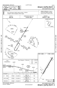
IAC chart of KSJS
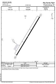
 ADC chart of KSJS
 Satellite view of KSJS
ADC chart of KSJS
Satellite view of KSJS
Sorry, we have no imagery here.
Sorry, we have no imagery here.
Sorry, we have no imagery here.
Sorry, we have no imagery here.
Sorry, we have no imagery here.
Sorry, we have no imagery here.


KSJS - Big Sandy Rgnl
Located in Prestonsburg, United States
ICAO - SJS, IATA -
Data provided by AirmateGeneral information
Coordinates: N37°45'3" W82°38'12"
Elevation is 1221 feet MSL.
Magnetic variation is -05° East View others Airports in Kentucky
Operational data
Special qualification required
Current time UTC:
Current local time:
Weather
METAR: KSJS 011755Z AUTO 00000KT 10SM OVC024 08/02 A3016 RMK AO2 T00780020 10078 20036
TAF: KSJS 011730Z 0118/0218 VRB03KT P6SM SCT250 FM020900 15007KT P6SM BKN250 WS020/20040KT FM021400 18012G22KT P6SM FEW100 SCT250
Communications frequencies: [VIEW]
Runways:
| RWY identifier | QFU | Length (ft) | Width (ft) | Surface | LDA (ft) |
| 03 | 31° | 5051 | 100 | ASPH | |
| 21 | 211° | 5051 | 100 | ASPH |
Airport contact information
Address: Prestonsburg United States
Satellite view of KSJS
Sorry, we have no imagery here.
Sorry, we have no imagery here.
Sorry, we have no imagery here.
Sorry, we have no imagery here.
Sorry, we have no imagery here.
Sorry, we have no imagery here.