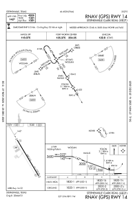
IAC chart of KSEP
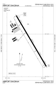
 ADC chart of KSEP
 Satellite view of KSEP
ADC chart of KSEP
Satellite view of KSEP
Sorry, we have no imagery here.
Sorry, we have no imagery here.
Sorry, we have no imagery here.
Sorry, we have no imagery here.
Sorry, we have no imagery here.
Sorry, we have no imagery here.


KSEP - Stephenville Clark Rgnl
Located in Stephenville, United States
ICAO - SEP, IATA -
Data provided by AirmateGeneral information
Coordinates: N32°12'55" W98°10'40"
Elevation is 1321 feet MSL.
Magnetic variation is 07° East View others Airports in Texas
Operational data
Special qualification required
Current time UTC:
Current local time:
Weather
METAR: KSEP 020835Z AUTO 17013G18KT 10SM OVC023 23/19 A2948 RMK AO2 T02270190
Communications frequencies: [VIEW]
Runways:
| RWY identifier | QFU | Length (ft) | Width (ft) | Surface | LDA (ft) |
| 14 | 149° | 4209 | 75 | ASPH | |
| 32 | 329° | 4209 | 75 | ASPH |
Airport contact information
Address: Stephenville United States
Satellite view of KSEP
Sorry, we have no imagery here.
Sorry, we have no imagery here.
Sorry, we have no imagery here.
Sorry, we have no imagery here.
Sorry, we have no imagery here.
Sorry, we have no imagery here.