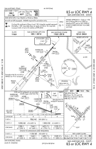
IAC chart of KSAT
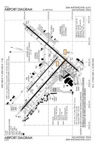
 ADC chart of KSAT
 Satellite view of KSAT
ADC chart of KSAT
Satellite view of KSAT
Sorry, we have no imagery here.
Sorry, we have no imagery here.
Sorry, we have no imagery here.
Sorry, we have no imagery here.
Sorry, we have no imagery here.
Sorry, we have no imagery here.


KSAT - San Antonio Intl
Located in San Antonio, United States
ICAO - SAT, IATA - SAT
Data provided by AirmateGeneral information
Coordinates: N29°32'2" W98°28'9"
Elevation is 809 feet MSL.
Magnetic variation is 04° East View others Airports in Texas
Operational data
Special qualification required
Current time UTC:
Current local time:
Weather
METAR: KSAT 020251Z 15017KT 10SM BKN022 OVC045 25/22 A2959 RMK AO2 SLP002 T02500217 53014
TAF: KSAT 020125Z 0201/0306 14017G27KT P6SM OVC028 FM020500 15012KT P6SM OVC017 FM021600 17010KT 6SM HZ OVC023 FM021800 08005KT P6SM BKN035 BKN250 FM030300 12011KT P6SM OVC025
Communications frequencies: [VIEW]
Runways:
| RWY identifier | QFU | Length (ft) | Width (ft) | Surface | LDA (ft) |
| 04 | 41° | 8505 | 150 | CONC | 8505 |
| 22 | 221° | 8505 | 150 | CONC | 8505 |
| 13L | 132° | 5519 | 100 | ASPH | 5519 |
| 31R | 312° | 5519 | 100 | ASPH | 5519 |
| 13R | 132° | 8502 | 150 | CONC | 8502 |
| 31L | 312° | 8502 | 150 | CONC | 8502 |
Airport contact information
Address: San Antonio United States
Other aviation service providers
Flight schools

Alpha Tango Flying Services, Inc.
Alpha Tango Flying Services, Inc.
alpha.tango@sbcglobal.net2108284480
Satellite view of KSAT
Sorry, we have no imagery here.
Sorry, we have no imagery here.
Sorry, we have no imagery here.
Sorry, we have no imagery here.
Sorry, we have no imagery here.
Sorry, we have no imagery here.