IAC chart of KRZT
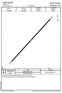
 ADC chart of KRZT
 Satellite view of KRZT
ADC chart of KRZT
Satellite view of KRZT
Sorry, we have no imagery here.
Sorry, we have no imagery here.
Sorry, we have no imagery here.
Sorry, we have no imagery here.
Sorry, we have no imagery here.
Sorry, we have no imagery here.


KRZT - Ross County
Located in Chillicothe, United States
ICAO - RZT, IATA -
Data provided by AirmateGeneral information
Coordinates: N39°26'26" W83°1'23"
Elevation is 725 feet MSL.
Magnetic variation is -05° East View others Airports in Ohio
Operational data
Special qualification required
Current time UTC:
Current local time:
Weather
METAR: KRZT 081335Z 10SM BKN032 M01/M09 A3015 RMK AO2 PWINO
Communications frequencies: [VIEW]
Runways:
| RWY identifier | QFU | Length (ft) | Width (ft) | Surface | LDA (ft) |
| 05 | 42° | 5405 | 100 | ASPH | |
| 23 | 222° | 5405 | 100 | ASPH |
Airport contact information
Address: Chillicothe United States
Satellite view of KRZT
Sorry, we have no imagery here.
Sorry, we have no imagery here.
Sorry, we have no imagery here.
Sorry, we have no imagery here.
Sorry, we have no imagery here.
Sorry, we have no imagery here.