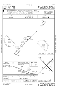
IAC chart of KRZN
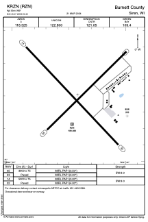
 ADC chart of KRZN
 Satellite view of KRZN
ADC chart of KRZN
Satellite view of KRZN
Sorry, we have no imagery here.
Sorry, we have no imagery here.
Sorry, we have no imagery here.
Sorry, we have no imagery here.
Sorry, we have no imagery here.
Sorry, we have no imagery here.


KRZN - Burnett County
Located in Siren, United States
ICAO - RZN, IATA -
Data provided by AirmateGeneral information
Coordinates: N45°49'24" W92°22'25"
Elevation is 989 feet MSL.
Magnetic variation is -01° East View others Airports in Wisconsin
Operational data
Special qualification required
Current time UTC:
Current local time:
Weather
METAR: KRZN 301735Z AUTO 30010G18KT 10SM CLR 22/08 A2987 RMK AO2 T02170077
Communications frequencies: [VIEW]
Runways:
| RWY identifier | QFU | Length (ft) | Width (ft) | Surface | LDA (ft) |
| 05 | 45° | 3900 | 75 | ASPH | |
| 23 | 225° | 3900 | 75 | ASPH | |
| 14 | 137° | 5000 | 75 | ASPH | |
| 32 | 317° | 5000 | 75 | ASPH |
Airport contact information
Address: Siren United States
Satellite view of KRZN
Sorry, we have no imagery here.
Sorry, we have no imagery here.
Sorry, we have no imagery here.
Sorry, we have no imagery here.
Sorry, we have no imagery here.
Sorry, we have no imagery here.