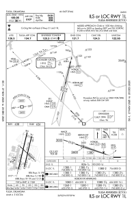
IAC chart of KRVS
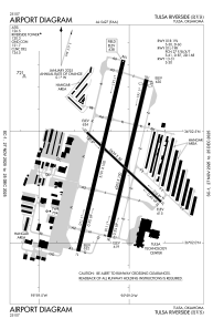
 ADC chart of KRVS
 Satellite view of KRVS
ADC chart of KRVS
Satellite view of KRVS
Sorry, we have no imagery here.
Sorry, we have no imagery here.
Sorry, we have no imagery here.
Sorry, we have no imagery here.
Sorry, we have no imagery here.
Sorry, we have no imagery here.


KRVS - Tulsa Riverside
Located in Tulsa, United States
ICAO - RVS, IATA -
Data provided by AirmateGeneral information
Coordinates: N36°2'23" W95°59'5"
Elevation is 637 feet MSL.
Magnetic variation is 03° East View others Airports in Oklahoma
Operational data
Special qualification required
Current time UTC:
Current local time:
Weather
METAR: KRVS 050953Z AUTO 36019G34KT 10SM OVC013 09/06 A2994 RMK AO2 PK WND 01034/0950 LTG DSNT S-W PRESFR SLP141 T00890061
TAF: KRVS 051011Z 0510/0606 01015G29KT 6SM -TSRA BR OVC012CB TEMPO 0511/0515 3SM TSRA BR OVC007CB FM060000 02012G20KT 6SM -SHRA BR BKN012 OVC025
Communications frequencies: [VIEW]
Runways:
| RWY identifier | QFU | Length (ft) | Width (ft) | Surface | LDA (ft) |
| 01L | 13° | 5101 | 100 | ASPH | |
| 19R | 193° | 5101 | 100 | ASPH | |
| 01R | 13° | 4205 | 100 | ASPH | |
| 19L | 193° | 4205 | 100 | ASPH | |
| 13 | 133° | 2639 | 50 | ASPH | |
| 31 | 313° | 2639 | 50 | ASPH |
Airport contact information
Address: Tulsa United States
Other aviation service providers
Flight schools

Atp Flight School (800-All-Atps)
Atp Flight School (800-All-Atps)
info@atpflightschool.com+1(800)255-2877
Christiansen Aviation Flight School
Christiansen Aviation Flight School
flightinfo@christiansenaviation.com+1(918)299-2646
Satellite view of KRVS
Sorry, we have no imagery here.
Sorry, we have no imagery here.
Sorry, we have no imagery here.
Sorry, we have no imagery here.
Sorry, we have no imagery here.
Sorry, we have no imagery here.