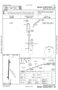
IAC chart of KRPB
 Satellite view of KRPB
Satellite view of KRPB
Sorry, we have no imagery here.
Sorry, we have no imagery here.
Sorry, we have no imagery here.
Sorry, we have no imagery here.
Sorry, we have no imagery here.
Sorry, we have no imagery here.


KRPB - Belleville Muni
Located in Belleville, United States
ICAO - RPB, IATA -
Data provided by AirmateGeneral information
Coordinates: N39°49'4" W97°39'35"
Elevation is 1538 feet MSL.
Magnetic variation is 07° East View others Airports in Kansas
Operational data
Special qualification required
Current time UTC:
Current local time:
Weather at : KCNK - Blosser Muni ( 30 km )
METAR: KCNK 112055Z AUTO 10SM CLR 21/00 A3020 RMK AO2 SLP226 T02110000 58035
Communications frequencies: [VIEW]
Runways:
| RWY identifier | QFU | Length (ft) | Width (ft) | Surface | LDA (ft) |
| 14 | 141° | 1415 | 100 | GRASS | |
| 32 | 321° | 1415 | 100 | GRASS | |
| 18 | 182° | 3500 | 60 | ASPH | |
| 36 | 2° | 3500 | 60 | ASPH |
Airport contact information
Address: Belleville United States
Satellite view of KRPB
Sorry, we have no imagery here.
Sorry, we have no imagery here.
Sorry, we have no imagery here.
Sorry, we have no imagery here.
Sorry, we have no imagery here.
Sorry, we have no imagery here.