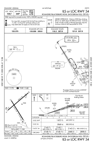
IAC chart of KROA
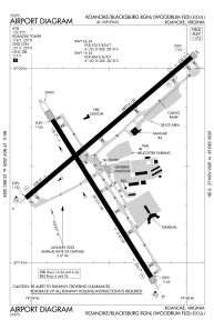
 ADC chart of KROA
 Satellite view of KROA
ADC chart of KROA
Satellite view of KROA
Sorry, we have no imagery here.
Sorry, we have no imagery here.
Sorry, we have no imagery here.
Sorry, we have no imagery here.
Sorry, we have no imagery here.
Sorry, we have no imagery here.


KROA - Roanoke/Blacksburg Rgnl (Woodrum Fld)
Located in Roanoke, United States
ICAO - ROA, IATA - ROA
Data provided by AirmateGeneral information
Coordinates: N37°19'32" W79°58'32"
Elevation is 1175 feet MSL.
Magnetic variation is -08° East View others Airports in Virginia
Operational data
Special qualification required
Current time UTC:
Current local time:
Weather
METAR: KROA 011454Z 29010KT 10SM CLR 11/M01 A3010 RMK AO2 SLP189 T01061006 51023
TAF: KROA 011120Z 0112/0212 32011KT P6SM SCT050 FM011600 34004KT P6SM SKC FM012200 12004KT P6SM SKC FM020900 11004KT P6SM OVC025
Communications frequencies: [VIEW]
Runways:
| RWY identifier | QFU | Length (ft) | Width (ft) | Surface | LDA (ft) |
| 06 | 50° | 6800 | 150 | ASPH | 6800 |
| 24 | 230° | 6800 | 150 | ASPH | 6010 |
| 16 | 148° | 5810 | 150 | ASPH | 5810 |
| 34 | 328° | 5810 | 150 | ASPH | 5810 |
Airport contact information
Address: Roanoke United States
Other aviation service providers
Flight schools

Satellite view of KROA
Sorry, we have no imagery here.
Sorry, we have no imagery here.
Sorry, we have no imagery here.
Sorry, we have no imagery here.
Sorry, we have no imagery here.
Sorry, we have no imagery here.