IAC chart of KRKP
 ADC chart of KRKP
 Satellite view of KRKP
ADC chart of KRKP
Satellite view of KRKP
Sorry, we have no imagery here.
Sorry, we have no imagery here.
Sorry, we have no imagery here.
Sorry, we have no imagery here.
Sorry, we have no imagery here.
Sorry, we have no imagery here.


KRKP - Aransas County
Located in Rockport, United States
ICAO - RKP, IATA -
Data provided by AirmateGeneral information
Coordinates: N28°5'10" W97°2'37"
Elevation is 23 feet MSL.
Magnetic variation is 06° East View others Airports in Texas
Operational data
Special qualification required
Current time UTC:
Current local time:
Weather
METAR: KRKP 021004Z AUTO 15014G25KT 4SM BR OVC007 24/23 A2954 RMK AO2 T02390228
Communications frequencies: [VIEW]
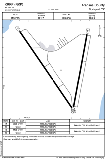
Runways:
| RWY identifier | QFU | Length (ft) | Width (ft) | Surface | LDA (ft) |
| 14 | 145° | 5608 | 100 | ASPH | |
| 32 | 325° | 5608 | 100 | ASPH | |
| 18 | 190° | 4498 | 100 | ASPH | |
| 36 | 10° | 4498 | 100 | ASPH |
Airport contact information
Address: Rockport United States
Satellite view of KRKP
Sorry, we have no imagery here.
Sorry, we have no imagery here.
Sorry, we have no imagery here.
Sorry, we have no imagery here.
Sorry, we have no imagery here.
Sorry, we have no imagery here.