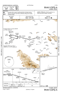
IAC chart of KRIR
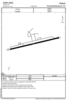
 ADC chart of KRIR
 Satellite view of KRIR
ADC chart of KRIR
Satellite view of KRIR
Sorry, we have no imagery here.
Sorry, we have no imagery here.
Sorry, we have no imagery here.
Sorry, we have no imagery here.
Sorry, we have no imagery here.
Sorry, we have no imagery here.


KRIR - Flabob
Located in Riverside/Rubidoux/, United States
ICAO - RIR, IATA -
Data provided by AirmateGeneral information
Coordinates: N33°59'20" W117°24'36"
Elevation is 767 feet MSL.
Magnetic variation is 13° East View others Airports in California
Operational data
Special qualification required
Current time UTC:
Current local time:
Weather at : KRAL - Riverside Muni ( 5 km )
METAR: KRAL 050853Z AUTO 05004KT 10SM CLR 12/03 A3017 RMK AO2 SLP203 T01170033 51003 $
Communications frequencies: [VIEW]
Runways:
| RWY identifier | QFU | Length (ft) | Width (ft) | Surface | LDA (ft) |
| 06 | 77° | 3190 | 50 | ASPH | |
| 24 | 257° | 3190 | 50 | ASPH |
Airport contact information
Address: Riverside/Rubidoux/ United States
Satellite view of KRIR
Sorry, we have no imagery here.
Sorry, we have no imagery here.
Sorry, we have no imagery here.
Sorry, we have no imagery here.
Sorry, we have no imagery here.
Sorry, we have no imagery here.