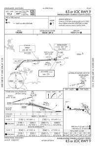
IAC chart of KRHI
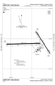
 ADC chart of KRHI
 Satellite view of KRHI
ADC chart of KRHI
Satellite view of KRHI
Sorry, we have no imagery here.
Sorry, we have no imagery here.
Sorry, we have no imagery here.
Sorry, we have no imagery here.
Sorry, we have no imagery here.
Sorry, we have no imagery here.


KRHI - Rhinelander/Oneida County
Located in Rhinelander, United States
ICAO - RHI, IATA - RHI
Data provided by AirmateGeneral information
Coordinates: N45°37'51" W89°27'60"
Elevation is 1623 feet MSL.
Magnetic variation is -03° East View others Airports in Wisconsin
Operational data
Special qualification required
Current time UTC:
Current local time:
Weather
METAR: KRHI 301853Z AUTO 31008G22KT 290V360 6SM HZ CLR 23/09 A2975 RMK AO2 SLP071 T02330094
TAF: KRHI 301739Z 3018/3118 31012G21KT 6SM FU SCT080 PROB30 3020/3023 -SHRA FM310000 01007KT 6SM FU SKC FM310300 01003KT P6SM SKC
Communications frequencies: [VIEW]
Runways:
| RWY identifier | QFU | Length (ft) | Width (ft) | Surface | LDA (ft) |
| 09 | 88° | 6800 | 150 | CONC | 6799 |
| 27 | 268° | 6800 | 150 | CONC | 6799 |
| 15 | 147° | 5201 | 100 | ASPH | 5201 |
| 33 | 327° | 5201 | 100 | ASPH | 5201 |
Airport contact information
Address: Rhinelander United States
Other aviation service providers
Flight schools

Satellite view of KRHI
Sorry, we have no imagery here.
Sorry, we have no imagery here.
Sorry, we have no imagery here.
Sorry, we have no imagery here.
Sorry, we have no imagery here.
Sorry, we have no imagery here.