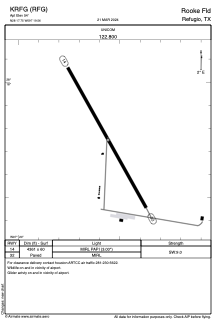
ADC chart of KRFG
 Satellite view of KRFG
Satellite view of KRFG
Sorry, we have no imagery here.
Sorry, we have no imagery here.
Sorry, we have no imagery here.
Sorry, we have no imagery here.
Sorry, we have no imagery here.
Sorry, we have no imagery here.


KRFG - Rooke Fld
Located in Refugio, United States
ICAO - RFG, IATA -
Data provided by AirmateGeneral information
Coordinates: N28°17'45" W97°19'33"
Elevation is 54 feet MSL.
Magnetic variation is 07° East View others Airports in Texas
Operational data
Special qualification required
Current time UTC:
Current local time:
Weather at : KRKP - Aransas County ( 36 km )
METAR: KRKP 020553Z AUTO 16014G26KT 6SM BR OVC009 24/22 A2960 RMK AO2 PK WND 17032/0541 SLP025 T02390222 10244 20233 58005
Communications frequencies: [VIEW]
Runways:
| RWY identifier | QFU | Length (ft) | Width (ft) | Surface | LDA (ft) |
| 14 | 151° | 4361 | 60 | ASPH | |
| 32 | 331° | 4361 | 60 | ASPH |
Airport contact information
Address: Refugio United States
Satellite view of KRFG
Sorry, we have no imagery here.
Sorry, we have no imagery here.
Sorry, we have no imagery here.
Sorry, we have no imagery here.
Sorry, we have no imagery here.
Sorry, we have no imagery here.