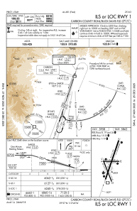
IAC chart of KPUC
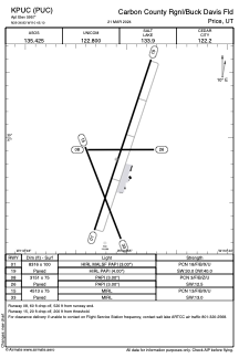
 ADC chart of KPUC
 Satellite view of KPUC
ADC chart of KPUC
Satellite view of KPUC
Sorry, we have no imagery here.
Sorry, we have no imagery here.
Sorry, we have no imagery here.
Sorry, we have no imagery here.
Sorry, we have no imagery here.
Sorry, we have no imagery here.


KPUC - Carbon County Rgnl/Buck Davis Fld
Located in Price, United States
ICAO - PUC, IATA -
Data provided by AirmateGeneral information
Coordinates: N39°36'50" W110°45'6"
Elevation is 5957 feet MSL.
Magnetic variation is 11° East View others Airports in Utah
Operational data
Special qualification required
Current time UTC:
Current local time:
Weather
METAR: KPUC 010753Z AUTO 29008KT 10SM BKN070 OVC080 02/M01 A2961 RMK AO2 SNE10 SLP018 P0000 T00171006
Communications frequencies: [VIEW]
Runways:
| RWY identifier | QFU | Length (ft) | Width (ft) | Surface | LDA (ft) |
| 01 | 18° | 8316 | 100 | ASPH | |
| 19 | 198° | 8316 | 100 | ASPH | |
| 08 | 90° | 3151 | 75 | ASPH | |
| 26 | 270° | 3151 | 75 | ASPH | |
| 15 | 158° | 4513 | 75 | ASPH | |
| 33 | 338° | 4513 | 75 | ASPH |
Airport contact information
Address: Price United States
Satellite view of KPUC
Sorry, we have no imagery here.
Sorry, we have no imagery here.
Sorry, we have no imagery here.
Sorry, we have no imagery here.
Sorry, we have no imagery here.
Sorry, we have no imagery here.