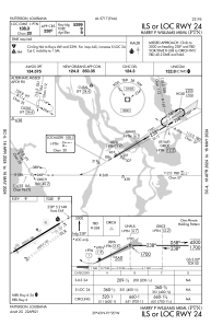
IAC chart of KPTN
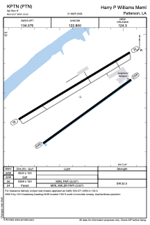
 ADC chart of KPTN
 Satellite view of KPTN
ADC chart of KPTN
Satellite view of KPTN
Sorry, we have no imagery here.
Sorry, we have no imagery here.
Sorry, we have no imagery here.
Sorry, we have no imagery here.
Sorry, we have no imagery here.


KPTN - Harry P Williams Meml
Located in Patterson, United States
ICAO - PTN, IATA -
Data provided by AirmateGeneral information
Coordinates: N29°42'34" W91°20'20"
Elevation is 8 feet MSL.
Magnetic variation is 01° East View others Airports in Louisiana
Operational data
Special qualification required
Current time UTC:
Current local time:
Weather
METAR: KPTN 082156Z AUTO VRB05KT 10SM CLR 21/04 A3010 RMK AO2 SLP191 T02110044 $
Communications frequencies: [VIEW]
Runways:
| RWY identifier | QFU | Length (ft) | Width (ft) | Surface | LDA (ft) |
| 04W | 55° | 4500 | 100 | WATER | |
| 22W | 235° | 4500 | 100 | WATER | |
| 06 | 59° | 5399 | 150 | ASPH | |
| 24 | 239° | 5399 | 150 | ASPH |
Airport contact information
Address: Patterson United States
Satellite view of KPTN
Sorry, we have no imagery here.
Sorry, we have no imagery here.
Sorry, we have no imagery here.
Sorry, we have no imagery here.
Sorry, we have no imagery here.