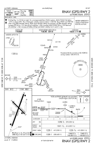
IAC chart of KPPO
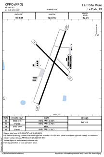
 ADC chart of KPPO
 Satellite view of KPPO
ADC chart of KPPO
Satellite view of KPPO
Sorry, we have no imagery here.
Sorry, we have no imagery here.
Sorry, we have no imagery here.
Sorry, we have no imagery here.
Sorry, we have no imagery here.
Sorry, we have no imagery here.


KPPO - La Porte Muni
Located in La Porte, United States
ICAO - PPO, IATA - LPO
Data provided by AirmateGeneral information
Coordinates: N41°34'21" W86°44'4"
Elevation is 812 feet MSL.
Magnetic variation is -03° East View others Airports in Indiana
Operational data
Special qualification required
Current time UTC:
Current local time:
Weather
METAR: KPPO 050755Z AUTO 01007KT 2SM -RA BR OVC004 06/06 A2991 RMK AO2 PRESFR VIS 1 1/2V3
Communications frequencies: [VIEW]
Runways:
| RWY identifier | QFU | Length (ft) | Width (ft) | Surface | LDA (ft) |
| 02 | 20° | 5000 | 75 | ASPH | |
| 20 | 200° | 5000 | 75 | ASPH | |
| 14 | 135° | 2797 | 60 | ASPH | |
| 32 | 315° | 2797 | 60 | ASPH |
Airport contact information
Address: La Porte United States
Other aviation service providers
Flight schools

Satellite view of KPPO
Sorry, we have no imagery here.
Sorry, we have no imagery here.
Sorry, we have no imagery here.
Sorry, we have no imagery here.
Sorry, we have no imagery here.
Sorry, we have no imagery here.