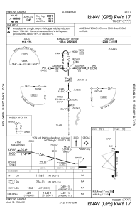
IAC chart of KPPF
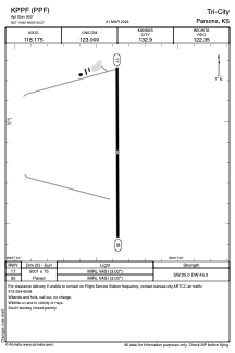
 ADC chart of KPPF
 Satellite view of KPPF
ADC chart of KPPF
Satellite view of KPPF
Sorry, we have no imagery here.
Sorry, we have no imagery here.
Sorry, we have no imagery here.
Sorry, we have no imagery here.
Sorry, we have no imagery here.
Sorry, we have no imagery here.


KPPF - Tri-City
Located in Parsons, United States
ICAO - PPF, IATA -
Data provided by AirmateGeneral information
Coordinates: N37°19'51" W95°30'22"
Elevation is 900 feet MSL.
Magnetic variation is 06° East View others Airports in Kansas
Operational data
Special qualification required
Current time UTC:
Current local time:
Weather
METAR: KPPF 111952Z AUTO VRB06G17KT 10SM CLR 21/03 A3026 RMK AO2 SLP245 T02060033
Communications frequencies: [VIEW]
Runways:
| RWY identifier | QFU | Length (ft) | Width (ft) | Surface | LDA (ft) |
| 17 | 180° | 5001 | 75 | CONC | |
| 35 | 360° | 5001 | 75 | CONC |
Airport contact information
Address: Parsons United States
Satellite view of KPPF
Sorry, we have no imagery here.
Sorry, we have no imagery here.
Sorry, we have no imagery here.
Sorry, we have no imagery here.
Sorry, we have no imagery here.
Sorry, we have no imagery here.