IAC chart of KPPA
 ADC chart of KPPA
 Satellite view of KPPA
ADC chart of KPPA
Satellite view of KPPA
Sorry, we have no imagery here.
Sorry, we have no imagery here.
Sorry, we have no imagery here.
Sorry, we have no imagery here.
Sorry, we have no imagery here.
Sorry, we have no imagery here.


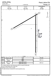
KPPA - Perry Lefors Fld
Located in Pampa, United States
ICAO - PPA, IATA -
Data provided by AirmateGeneral information
Coordinates: N35°36'47" W100°59'47"
Elevation is 3245 feet MSL.
Magnetic variation is 06° East View others Airports in Texas
Operational data
Special qualification required
Current time UTC:
Current local time:
Weather
METAR: KPPA 021255Z AUTO 27015G20KT 10SM CLR 09/M07 A2959 RMK AO2 T00861073
Communications frequencies: [VIEW]
Runways:
| RWY identifier | QFU | Length (ft) | Width (ft) | Surface | LDA (ft) |
| 05 | 60° | 4500 | 75 | ASPH | |
| 23 | 240° | 4500 | 75 | ASPH | |
| 17 | 180° | 5862 | 100 | ASPH | |
| 35 | 0° | 5862 | 100 | ASPH |
Airport contact information
Address: Pampa United States
Satellite view of KPPA
Sorry, we have no imagery here.
Sorry, we have no imagery here.
Sorry, we have no imagery here.
Sorry, we have no imagery here.
Sorry, we have no imagery here.
Sorry, we have no imagery here.