IAC chart of KPOY
 ADC chart of KPOY
 Satellite view of KPOY
ADC chart of KPOY
Satellite view of KPOY
Sorry, we have no imagery here.
Sorry, we have no imagery here.
Sorry, we have no imagery here.
Sorry, we have no imagery here.
Sorry, we have no imagery here.
Sorry, we have no imagery here.


KPOY - Powell Muni
Located in Powell, United States
ICAO - POY, IATA -
Data provided by AirmateGeneral information
Coordinates: N44°52'2" W108°47'36"
Elevation is 5095 feet MSL.
Magnetic variation is 11° East View others Airports in Wyoming
Operational data
Special qualification required
Current time UTC:
Current local time:
Weather
METAR: KPOY 080635Z AUTO 23010KT 10SM CLR 10/M06 A2986 RMK AO2
Communications frequencies: [VIEW]
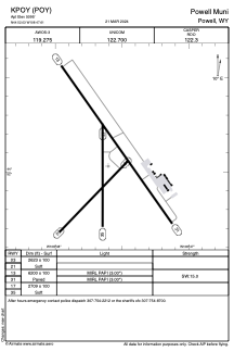
Runways:
| RWY identifier | QFU | Length (ft) | Width (ft) | Surface | LDA (ft) |
| 03 | 44° | 2623 | 100 | OTHER | |
| 21 | 224° | 2623 | 100 | OTHER | |
| 13 | 145° | 6200 | 100 | ASPH | |
| 31 | 325° | 6200 | 100 | ASPH | |
| 17 | 180° | 2709 | 100 | OTHER | |
| 35 | 0° | 2709 | 100 | OTHER |
Airport contact information
Address: Powell United States
Satellite view of KPOY
Sorry, we have no imagery here.
Sorry, we have no imagery here.
Sorry, we have no imagery here.
Sorry, we have no imagery here.
Sorry, we have no imagery here.
Sorry, we have no imagery here.