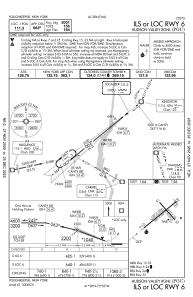
IAC chart of KPOU
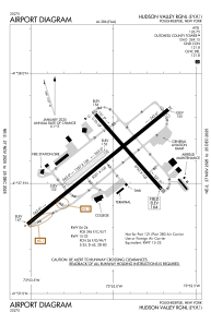
 ADC chart of KPOU
 Satellite view of KPOU
ADC chart of KPOU
Satellite view of KPOU
Sorry, we have no imagery here.
Sorry, we have no imagery here.
Sorry, we have no imagery here.
Sorry, we have no imagery here.
Sorry, we have no imagery here.
Sorry, we have no imagery here.


KPOU - Hudson Valley Rgnl
Located in Poughkeepsie, United States
ICAO - POU, IATA - POU
Data provided by AirmateGeneral information
Coordinates: N41°37'36" W73°53'3"
Elevation is 163 feet MSL.
Magnetic variation is -12° East View others Airports in New York
Operational data
Special qualification required
Current time UTC:
Current local time:
Weather
METAR: KPOU 070153Z AUTO 03007KT 10SM SCT041 OVC065 09/M02 A2988 RMK AO2 SLP116 T00941022
TAF: KPOU 062320Z 0700/0724 35004KT P6SM BKN060 OVC080 FM070600 36003KT 4SM -RA BR OVC030 TEMPO 0708/0712 2SM -RASN BR OVC020 FM071500 04004KT P6SM VCSH OVC020
Communications frequencies: [VIEW]
Runways:
| RWY identifier | QFU | Length (ft) | Width (ft) | Surface | LDA (ft) |
| 06 | 51° | 5001 | 100 | ASPH | 5001 |
| 24 | 231° | 5001 | 100 | ASPH | 4886 |
| 07 | 51° | 1357 | 100 | GRASS | |
| 25 | 231° | 1357 | 100 | GRASS | |
| 15 | 139° | 2743 | 100 | OTHER | 2743 |
| 33 | 319° | 2743 | 100 | OTHER | 2743 |
Airport contact information
Address: Poughkeepsie United States
Satellite view of KPOU
Sorry, we have no imagery here.
Sorry, we have no imagery here.
Sorry, we have no imagery here.
Sorry, we have no imagery here.
Sorry, we have no imagery here.
Sorry, we have no imagery here.