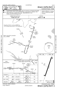
IAC chart of KPMZ
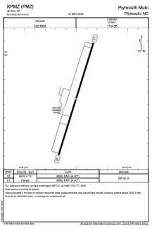
 ADC chart of KPMZ
 Satellite view of KPMZ
ADC chart of KPMZ
Satellite view of KPMZ
Sorry, we have no imagery here.
Sorry, we have no imagery here.
Sorry, we have no imagery here.
Sorry, we have no imagery here.
Sorry, we have no imagery here.
Sorry, we have no imagery here.


KPMZ - Plymouth Muni
Located in Plymouth, United States
ICAO - PMZ, IATA -
Data provided by AirmateGeneral information
Coordinates: N35°48'39" W76°45'30"
Elevation is 36 feet MSL.
Magnetic variation is -10° East View others Airports in North Carolina
Operational data
Special qualification required
Current time UTC:
Current local time:
Weather at : KEDE - Northeastern Rgnl ( 30 km )
METAR: KEDE 020250Z AUTO 05004KT 10SM CLR 11/08 A3024 RMK AO2 T01120081
Communications frequencies: [VIEW]
Runways:
| RWY identifier | QFU | Length (ft) | Width (ft) | Surface | LDA (ft) |
| 03 | 17° | 5500 | 75 | ASPH | |
| 21 | 197° | 5500 | 75 | ASPH |
Airport contact information
Address: Plymouth United States
Satellite view of KPMZ
Sorry, we have no imagery here.
Sorry, we have no imagery here.
Sorry, we have no imagery here.
Sorry, we have no imagery here.
Sorry, we have no imagery here.
Sorry, we have no imagery here.