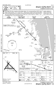
IAC chart of KPIL
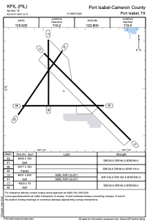
 ADC chart of KPIL
 Satellite view of KPIL
ADC chart of KPIL
Satellite view of KPIL
Sorry, we have no imagery here.
Sorry, we have no imagery here.
Sorry, we have no imagery here.
Sorry, we have no imagery here.
Sorry, we have no imagery here.
Sorry, we have no imagery here.


KPIL - Port Isabel-Cameron County
Located in Port Isabel, United States
ICAO - PIL, IATA -
Data provided by AirmateGeneral information
Coordinates: N26°9'58" W97°20'45"
Elevation is 18 feet MSL.
Magnetic variation is 05° East View others Airports in Texas
Operational data
Special qualification required
Current time UTC:
Current local time:
Weather
METAR: KPIL 020853Z AUTO 16019G30KT 7SM OVC014 25/23 A2956 RMK AO2 PK WND 17030/0853 SLP009 T02500233 56021
Communications frequencies: [VIEW]
Runways:
| RWY identifier | QFU | Length (ft) | Width (ft) | Surface | LDA (ft) |
| 03 | 35° | 5000 | 150 | OTHER | |
| 21 | 215° | 5000 | 150 | OTHER | |
| 08 | 90° | 5317 | 150 | CONC | |
| 26 | 270° | 5317 | 150 | CONC | |
| 13 | 135° | 8001 | 200 | OTHER | |
| 31 | 315° | 8001 | 200 | OTHER | |
| 17 | 180° | 4200 | 75 | OTHER | |
| 35 | 360° | 4200 | 75 | OTHER |
Airport contact information
Address: Port Isabel United States
Satellite view of KPIL
Sorry, we have no imagery here.
Sorry, we have no imagery here.
Sorry, we have no imagery here.
Sorry, we have no imagery here.
Sorry, we have no imagery here.
Sorry, we have no imagery here.