IAC chart of KPHG
 ADC chart of KPHG
 Satellite view of KPHG
ADC chart of KPHG
Satellite view of KPHG
Sorry, we have no imagery here.
Sorry, we have no imagery here.
Sorry, we have no imagery here.
Sorry, we have no imagery here.
Sorry, we have no imagery here.
Sorry, we have no imagery here.


KPHG - Phillipsburg Muni
Located in Phillipsburg, United States
ICAO - PHG, IATA -
Data provided by AirmateGeneral information
Coordinates: N39°44'8" W99°19'3"
Elevation is 1909 feet MSL.
Magnetic variation is 05° East View others Airports in Kansas
Operational data
Special qualification required
Current time UTC:
Current local time:
Weather
METAR: KPHG 111135Z AUTO 31008KT 10SM CLR 00/M04 A3032 RMK AO2
Communications frequencies: [VIEW]
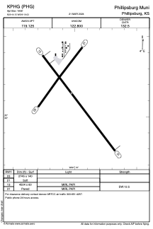
Runways:
| RWY identifier | QFU | Length (ft) | Width (ft) | Surface | LDA (ft) |
| 03 | 36° | 1755 | 140 | GRASS | |
| 21 | 216° | 1755 | 140 | GRASS | |
| 13 | 143° | 5101 | 75 | CONC | |
| 31 | 323° | 5101 | 75 | CONC |
Airport contact information
Address: Phillipsburg United States
Satellite view of KPHG
Sorry, we have no imagery here.
Sorry, we have no imagery here.
Sorry, we have no imagery here.
Sorry, we have no imagery here.
Sorry, we have no imagery here.
Sorry, we have no imagery here.