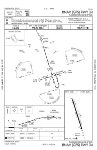
IAC chart of KPEZ
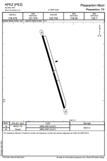
 ADC chart of KPEZ
 Satellite view of KPEZ
ADC chart of KPEZ
Satellite view of KPEZ
Sorry, we have no imagery here.
Sorry, we have no imagery here.
Sorry, we have no imagery here.
Sorry, we have no imagery here.
Sorry, we have no imagery here.
Sorry, we have no imagery here.


KPEZ - Pleasanton Muni
Located in Pleasanton, United States
ICAO - PEZ, IATA -
Data provided by AirmateGeneral information
Coordinates: N28°57'15" W98°31'12"
Elevation is 430 feet MSL.
Magnetic variation is 06° East View others Airports in Texas
Operational data
Special qualification required
Current time UTC:
Current local time:
Weather
METAR: KPEZ 020835Z AUTO 15010G18KT 10SM BKN015 23/20 A2954 RMK AO2 T02260202
Communications frequencies: [VIEW]
Runways:
| RWY identifier | QFU | Length (ft) | Width (ft) | Surface | LDA (ft) |
| 16 | 163° | 4000 | 75 | ASPH | |
| 34 | 343° | 4000 | 75 | ASPH |
Airport contact information
Address: Pleasanton United States
Satellite view of KPEZ
Sorry, we have no imagery here.
Sorry, we have no imagery here.
Sorry, we have no imagery here.
Sorry, we have no imagery here.
Sorry, we have no imagery here.
Sorry, we have no imagery here.