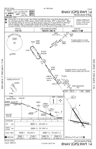
IAC chart of KPEQ
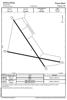
 ADC chart of KPEQ
 Satellite view of KPEQ
ADC chart of KPEQ
Satellite view of KPEQ
Sorry, we have no imagery here.
Sorry, we have no imagery here.
Sorry, we have no imagery here.
Sorry, we have no imagery here.
Sorry, we have no imagery here.
Sorry, we have no imagery here.


KPEQ - Pecos Muni
Located in Pecos, United States
ICAO - PEQ, IATA -
Data provided by AirmateGeneral information
Coordinates: N31°22'57" W103°30'39"
Elevation is 2613 feet MSL.
Magnetic variation is 09° East View others Airports in Texas
Operational data
Special qualification required
Current time UTC:
Current local time:
Weather
TAF: KPEQ 021143Z 0212/0312 34012KT P6SM SCT250 FM021400 30008KT P6SM SCT250 FM021700 26011KT P6SM SCT150 BKN250 FM030100 31008KT P6SM SCT100 BKN200 AMD NOT SKED
Communications frequencies: [VIEW]
Runways:
| RWY identifier | QFU | Length (ft) | Width (ft) | Surface | LDA (ft) |
| 09 | 101° | 5953 | 80 | ASPH | |
| 27 | 281° | 5953 | 80 | ASPH | |
| 14 | 146° | 6236 | 80 | ASPH | |
| 32 | 326° | 6236 | 80 | ASPH |
Airport contact information
Address: Pecos United States
Satellite view of KPEQ
Sorry, we have no imagery here.
Sorry, we have no imagery here.
Sorry, we have no imagery here.
Sorry, we have no imagery here.
Sorry, we have no imagery here.
Sorry, we have no imagery here.