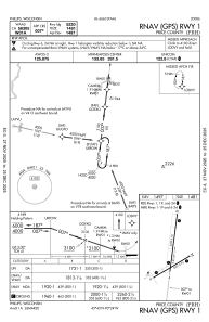
IAC chart of KPBH
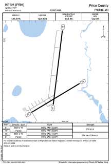
 ADC chart of KPBH
 Satellite view of KPBH
ADC chart of KPBH
Satellite view of KPBH
Sorry, we have no imagery here.
Sorry, we have no imagery here.
Sorry, we have no imagery here.
Sorry, we have no imagery here.
Sorry, we have no imagery here.
Sorry, we have no imagery here.


KPBH - Price County
Located in Phillips, United States
ICAO - PBH, IATA -
Data provided by AirmateGeneral information
Coordinates: N45°42'32" W90°24'9"
Elevation is 1497 feet MSL.
Magnetic variation is 00° East View others Airports in Wisconsin
Operational data
Special qualification required
Current time UTC:
Current local time:
Weather
METAR: KPBH 221415Z AUTO 35007KT 320V040 10SM BKN033 OVC050 09/02 A3005 RMK AO2 T00870017
Communications frequencies: [VIEW]
Runways:
| RWY identifier | QFU | Length (ft) | Width (ft) | Surface | LDA (ft) |
| 01 | 7° | 5220 | 75 | ASPH | |
| 19 | 187° | 5220 | 75 | ASPH | |
| 06 | 59° | 3951 | 75 | ASPH | |
| 24 | 239° | 3951 | 75 | ASPH |
Airport contact information
Address: Phillips United States
Satellite view of KPBH
Sorry, we have no imagery here.
Sorry, we have no imagery here.
Sorry, we have no imagery here.
Sorry, we have no imagery here.
Sorry, we have no imagery here.
Sorry, we have no imagery here.