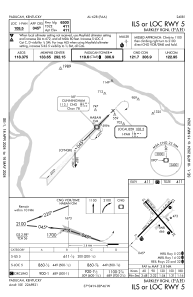
IAC chart of KPAH
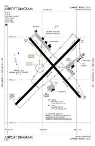
 ADC chart of KPAH
 Satellite view of KPAH
ADC chart of KPAH
Satellite view of KPAH
Sorry, we have no imagery here.
Sorry, we have no imagery here.
Sorry, we have no imagery here.
Sorry, we have no imagery here.
Sorry, we have no imagery here.
Sorry, we have no imagery here.


KPAH - Barkley Rgnl
Located in Paducah, United States
ICAO - PAH, IATA - PAH
Data provided by AirmateGeneral information
Coordinates: N37°3'37" W88°46'23"
Elevation is 410 feet MSL.
Magnetic variation is -01° East View others Airports in Kentucky
Operational data
Special qualification required
Current time UTC:
Current local time:
Weather
METAR: KPAH 020153Z 11010KT 10SM CLR 15/06 A2984 RMK AO2 SLPNO T01500061
TAF: KPAH 012323Z 0200/0224 13008KT P6SM BKN250 FM020500 14010G19KT P6SM BKN050 FM021000 17014G25KT P6SM VCSH OVC015 FM021400 19018G39KT P6SM OVC020 FM021800 20022G40KT P6SM BKN040 FM022200 20020G33KT 5SM -SHRA BR BKN030 PROB30 0222/0224 1SM TSRA BKN020CB
Communications frequencies: [VIEW]
Runways:
| RWY identifier | QFU | Length (ft) | Width (ft) | Surface | LDA (ft) |
| 05 | 44° | 6500 | 150 | ASPH | 6500 |
| 23 | 224° | 6500 | 150 | ASPH | 6500 |
| 14 | 139° | 5499 | 150 | ASPH | 5399 |
| 32 | 319° | 5499 | 150 | ASPH | 5324 |
Airport contact information
Address: Paducah United States

Satellite view of KPAH
Sorry, we have no imagery here.
Sorry, we have no imagery here.
Sorry, we have no imagery here.
Sorry, we have no imagery here.
Sorry, we have no imagery here.
Sorry, we have no imagery here.