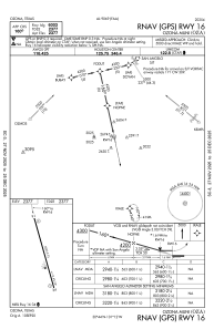
IAC chart of KOZA
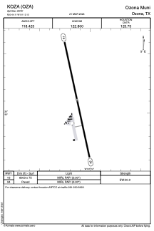
 ADC chart of KOZA
 Satellite view of KOZA
ADC chart of KOZA
Satellite view of KOZA
Sorry, we have no imagery here.
Sorry, we have no imagery here.
Sorry, we have no imagery here.
Sorry, we have no imagery here.
Sorry, we have no imagery here.
Sorry, we have no imagery here.


KOZA - Ozona Muni
Located in Ozona, United States
ICAO - OZA, IATA -
Data provided by AirmateGeneral information
Coordinates: N30°44'7" W101°12'8"
Elevation is 2376 feet MSL.
Magnetic variation is 08° East View others Airports in Texas
Operational data
Special qualification required
Current time UTC:
Current local time:
Weather
METAR: KOZA 021255Z AUTO 36016G20KT 2 1/2SM HZ CLR 17/00 A2968 RMK AO2
Communications frequencies: [VIEW]
Runways:
| RWY identifier | QFU | Length (ft) | Width (ft) | Surface | LDA (ft) |
| 16 | 168° | 6003 | 75 | ASPH | |
| 34 | 348° | 6003 | 75 | ASPH |
Airport contact information
Address: Ozona United States
Satellite view of KOZA
Sorry, we have no imagery here.
Sorry, we have no imagery here.
Sorry, we have no imagery here.
Sorry, we have no imagery here.
Sorry, we have no imagery here.
Sorry, we have no imagery here.