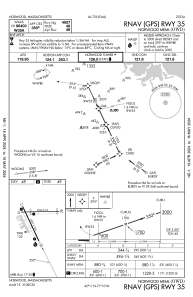
IAC chart of KOWD
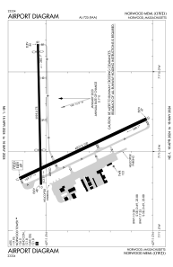
 ADC chart of KOWD
 Satellite view of KOWD
ADC chart of KOWD
Satellite view of KOWD
Sorry, we have no imagery here.
Sorry, we have no imagery here.
Sorry, we have no imagery here.
Sorry, we have no imagery here.
Sorry, we have no imagery here.
Sorry, we have no imagery here.


KOWD - Norwood Meml
Located in Norwood, United States
ICAO - OWD, IATA - OWD
Data provided by AirmateGeneral information
Coordinates: N42°11'26" W71°10'23"
Elevation is 49 feet MSL.
Magnetic variation is -15° East View others Airports in Massachusetts
Operational data
Special qualification required
Current time UTC:
Current local time:
Weather
METAR: KOWD 011553Z 32017G24KT 10SM CLR 11/M02 A2983 RMK AO2 SLP101 T01111022
Communications frequencies: [VIEW]
Runways:
| RWY identifier | QFU | Length (ft) | Width (ft) | Surface | LDA (ft) |
| 10 | 89° | 3995 | 75 | ASPH | 2795 |
| 28 | 269° | 3995 | 75 | ASPH | 3595 |
| 17 | 155° | 4007 | 100 | ASPH | |
| 35 | 335° | 4007 | 100 | ASPH |
Airport contact information
Address: Norwood United States
Other aviation service providers
Flight schools

Satellite view of KOWD
Sorry, we have no imagery here.
Sorry, we have no imagery here.
Sorry, we have no imagery here.
Sorry, we have no imagery here.
Sorry, we have no imagery here.
Sorry, we have no imagery here.