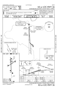
IAC chart of KOWB
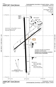
 ADC chart of KOWB
 Satellite view of KOWB
ADC chart of KOWB
Satellite view of KOWB
Sorry, we have no imagery here.
Sorry, we have no imagery here.
Sorry, we have no imagery here.
Sorry, we have no imagery here.
Sorry, we have no imagery here.


KOWB - Owensboro/Daviess County Rgnl
Located in Owensboro, United States
ICAO - OWB, IATA - OWB
Data provided by AirmateGeneral information
Coordinates: N37°44'20" W87°10'1"
Elevation is 407 feet MSL.
Magnetic variation is -04° East View others Airports in Kentucky
Operational data
Special qualification required
Current time UTC:
Current local time:
Weather
TAF: KOWB 021140Z 0212/0312 17017G27KT P6SM BKN110 WS020/18050KT FM021400 19021G36KT P6SM BKN022 FM021800 19026G42KT P6SM BKN035 PROB30 0220/0301 4SM TSRA OVC025CB FM030100 20023G35KT 6SM -TSRA BKN040CB TEMPO 0301/0303 VRB35G50KT 1SM +TSRA BKN025CB FM030300 20022G31KT 5SM -TSRA OVC025CB FM030700 24005KT P6SM OVC027
Communications frequencies: [VIEW]
Runways:
| RWY identifier | QFU | Length (ft) | Width (ft) | Surface | LDA (ft) |
| 06 | 52° | 5000 | 100 | OTHER | 5000 |
| 24 | 232° | 5000 | 100 | OTHER | 5000 |
| 18 | 178° | 8000 | 150 | CONC | 8000 |
| 36 | 358° | 8000 | 150 | CONC | 8000 |
Airport contact information
Address: Owensboro United States
Other aviation service providers
Repair station

Flight schools

Satellite view of KOWB
Sorry, we have no imagery here.
Sorry, we have no imagery here.
Sorry, we have no imagery here.
Sorry, we have no imagery here.
Sorry, we have no imagery here.