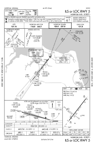
IAC chart of KORF
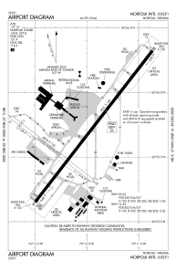
 ADC chart of KORF
 Satellite view of KORF
ADC chart of KORF
Satellite view of KORF
Sorry, we have no imagery here.
Sorry, we have no imagery here.
Sorry, we have no imagery here.
Sorry, we have no imagery here.
Sorry, we have no imagery here.
Sorry, we have no imagery here.


KORF - Norfolk Intl
Located in Norfolk, United States
ICAO - ORF, IATA - ORF
Data provided by AirmateGeneral information
Coordinates: N36°53'41" W76°12'4"
Elevation is 26 feet MSL.
Magnetic variation is -09° East View others Airports in Virginia
Operational data
Special qualification required
Current time UTC:
Current local time:
Weather
METAR: KORF 011451Z 35011G21KT 10SM BKN050 13/04 A3000 RMK AO2 SLP157 T01280039 52033
TAF: KORF 011120Z 0112/0212 35014G22KT P6SM SCT025 BKN035 TEMPO 0112/0114 BKN025 FM011600 01010G18KT P6SM SKC FM012200 05006KT P6SM SKC
Communications frequencies: [VIEW]
Runways:
| RWY identifier | QFU | Length (ft) | Width (ft) | Surface | LDA (ft) |
| 05 | 38° | 9001 | 150 | OTHER | 7809 |
| 23 | 218° | 9001 | 150 | OTHER | 8995 |
| 14 | 128° | 4876 | 150 | ASPH | 4301 |
| 32 | 308° | 4876 | 150 | ASPH | 3901 |
Airport contact information
Address: Norfolk United States
Satellite view of KORF
Sorry, we have no imagery here.
Sorry, we have no imagery here.
Sorry, we have no imagery here.
Sorry, we have no imagery here.
Sorry, we have no imagery here.
Sorry, we have no imagery here.