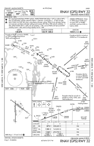
IAC chart of KORE
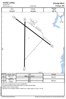
 ADC chart of KORE
 Satellite view of KORE
ADC chart of KORE
Satellite view of KORE
Sorry, we have no imagery here.
Sorry, we have no imagery here.
Sorry, we have no imagery here.
Sorry, we have no imagery here.
Sorry, we have no imagery here.
Sorry, we have no imagery here.


KORE - Orange Muni
Located in Orange, United States
ICAO - ORE, IATA -
Data provided by AirmateGeneral information
Coordinates: N42°34'12" W72°17'19"
Elevation is 555 feet MSL.
Magnetic variation is -15° East View others Airports in Massachusetts
Operational data
Special qualification required
Current time UTC:
Current local time:
Weather
METAR: KORE 011452Z AUTO 32017G22KT 10SM BKN032 05/M03 A2987 RMK AO2 SLP118 T00501028 51039
Communications frequencies: [VIEW]
Runways:
| RWY identifier | QFU | Length (ft) | Width (ft) | Surface | LDA (ft) |
| 01 | 1° | 5001 | 75 | ASPH | |
| 19 | 181° | 5001 | 75 | ASPH | |
| 14 | 127° | 4800 | 75 | ASPH | |
| 32 | 307° | 4800 | 75 | ASPH |
Airport contact information
Address: Orange United States
Other aviation service providers
Flight schools

Satellite view of KORE
Sorry, we have no imagery here.
Sorry, we have no imagery here.
Sorry, we have no imagery here.
Sorry, we have no imagery here.
Sorry, we have no imagery here.
Sorry, we have no imagery here.