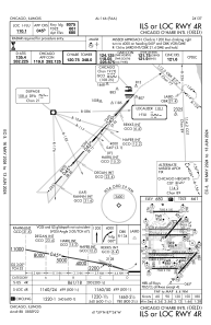
IAC chart of KORD
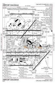
 ADC chart of KORD
 Satellite view of KORD
ADC chart of KORD
Satellite view of KORD
Sorry, we have no imagery here.
Sorry, we have no imagery here.
Sorry, we have no imagery here.
Sorry, we have no imagery here.
Sorry, we have no imagery here.
Sorry, we have no imagery here.


KORD - Chicago O'hare Intl
Located in Chicago, United States
ICAO - ORD, IATA - ORD
Data provided by AirmateGeneral information
Coordinates: N41°58'37" W87°54'29"
Elevation is 680 feet MSL.
Magnetic variation is -03° East View others Airports in Illinois
Operational data
Special qualification required
Current time UTC:
Current local time:
Weather
METAR: KORD 082051Z 29008KT 10SM FEW250 06/M13 A3012 RMK AO2 SLP207 T00611128 56017 $
TAF: KORD 081927Z 0819/0924 09010KT P6SM FEW060 FM090600 16005KT P6SM BKN250 FM091000 18010KT P6SM OVC100 FM091500 17013G23KT P6SM -SHRA SCT015 OVC050 FM091800 15011G21KT 3SM -RA BR OVC012 TEMPO 0919/0923 2SM RA BR OVC008
Communications frequencies: [VIEW]
Runways:
| RWY identifier | QFU | Length (ft) | Width (ft) | Surface | LDA (ft) |
| 04L | 39° | 7500 | 150 | ASPH | |
| 22R | 219° | 7500 | 150 | ASPH | 7300 |
| 04R | 42° | 8075 | 150 | ASPH | 8075 |
| 22L | 222° | 8075 | 150 | ASPH | 8075 |
| 09C | 90° | 11245 | 200 | CONC | 11245 |
| 27C | 270° | 11245 | 200 | CONC | 11245 |
| 09L | 90° | 7500 | 150 | CONC | 7500 |
| 27R | 270° | 7500 | 150 | CONC | 7500 |
| 09R | 90° | 11260 | 150 | OTHER | 11260 |
| 27L | 270° | 11260 | 150 | OTHER | 11260 |
| 10C | 90° | 10800 | 200 | CONC | 10540 |
| 28C | 270° | 10800 | 200 | CONC | 10800 |
| 10L | 90° | 13000 | 150 | OTHER | 12246 |
| 28R | 270° | 13000 | 150 | OTHER | 13000 |
| 10R | 90° | 7500 | 150 | CONC | 7500 |
| 28L | 270° | 7500 | 150 | CONC | 7500 |
| H1 | 0° | 0 | 0 | UNK |
Airport contact information
Address: Chicago United States
Satellite view of KORD
Sorry, we have no imagery here.
Sorry, we have no imagery here.
Sorry, we have no imagery here.
Sorry, we have no imagery here.
Sorry, we have no imagery here.
Sorry, we have no imagery here.