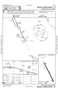
IAC chart of KOQW
 Satellite view of KOQW
Satellite view of KOQW
Sorry, we have no imagery here.
Sorry, we have no imagery here.
Sorry, we have no imagery here.
Sorry, we have no imagery here.
Sorry, we have no imagery here.
Sorry, we have no imagery here.


KOQW - Maquoketa Muni
Located in Maquoketa, United States
ICAO - OQW, IATA -
Data provided by AirmateGeneral information
Coordinates: N42°3'0" W90°44'20"
Elevation is 769 feet MSL.
Magnetic variation is 00° East View others Airports in Iowa
Operational data
Special qualification required
Current time UTC:
Current local time:
Weather at : KDBQ - Dubuque Rgnl ( 39 km )
METAR: KDBQ 151253Z 16005KT 7SM CLR 23/20 A3006 RMK AO2 SLP173 T02280200 $
TAF: KDBQ 151120Z 1512/1612 18009KT P6SM SCT200 TEMPO 1512/1513 5SM BR
Communications frequencies: [VIEW]
Runways:
| RWY identifier | QFU | Length (ft) | Width (ft) | Surface | LDA (ft) |
| 15 | 155° | 3304 | 60 | CONC | |
| 33 | 335° | 3304 | 60 | CONC |
Airport contact information
Address: Maquoketa United States
Satellite view of KOQW
Sorry, we have no imagery here.
Sorry, we have no imagery here.
Sorry, we have no imagery here.
Sorry, we have no imagery here.
Sorry, we have no imagery here.
Sorry, we have no imagery here.