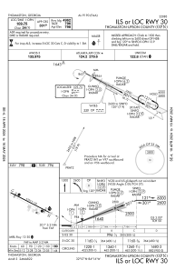
IAC chart of KOPN
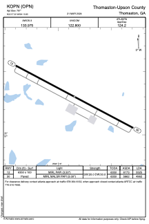
 ADC chart of KOPN
 Satellite view of KOPN
ADC chart of KOPN
Satellite view of KOPN
Sorry, we have no imagery here.
Sorry, we have no imagery here.
Sorry, we have no imagery here.
Sorry, we have no imagery here.
Sorry, we have no imagery here.


KOPN - Thomaston-Upson County
Located in Thomaston, United States
ICAO - OPN, IATA -
Data provided by AirmateGeneral information
Coordinates: N32°57'18" W84°15'51"
Elevation is 797 feet MSL.
Magnetic variation is -03° East View others Airports in Georgia
Operational data
Special qualification required
Current time UTC:
Current local time:
Weather
METAR: KOPN 051355Z AUTO 21004KT 10SM CLR 22/18 A3021 RMK AO2
Communications frequencies: [VIEW]
Runways:
| RWY identifier | QFU | Length (ft) | Width (ft) | Surface | LDA (ft) |
| 12 | 118° | 6350 | 100 | ASPH | 5525 |
| 30 | 298° | 6350 | 100 | ASPH | 4962 |
Airport contact information
Address: Thomaston United States
Other aviation service providers
Repair station

Flight schools

Satellite view of KOPN
Sorry, we have no imagery here.
Sorry, we have no imagery here.
Sorry, we have no imagery here.
Sorry, we have no imagery here.
Sorry, we have no imagery here.