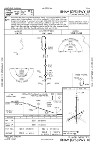
IAC chart of KOPL
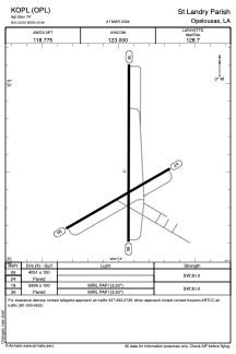
 ADC chart of KOPL
 Satellite view of KOPL
ADC chart of KOPL
Satellite view of KOPL
Sorry, we have no imagery here.
Sorry, we have no imagery here.
Sorry, we have no imagery here.
Sorry, we have no imagery here.
Sorry, we have no imagery here.
Sorry, we have no imagery here.


KOPL - St Landry Parish
Located in Opelousas, United States
ICAO - OPL, IATA -
Data provided by AirmateGeneral information
Coordinates: N30°33'30" W92°5'58"
Elevation is 74 feet MSL.
Magnetic variation is 01° East View others Airports in Louisiana
Operational data
Special qualification required
Current time UTC:
Current local time:
Weather
METAR: KOPL 071115Z AUTO 00000KT 10SM OVC009 10/08 A2995 RMK AO2 T00980084
Communications frequencies: [VIEW]
Runways:
| RWY identifier | QFU | Length (ft) | Width (ft) | Surface | LDA (ft) |
| 06 | 60° | 4051 | 100 | CONC | |
| 24 | 240° | 4051 | 100 | CONC | |
| 18 | 180° | 5999 | 100 | CONC | |
| 36 | 0° | 5999 | 100 | CONC |
Airport contact information
Address: Opelousas United States
Satellite view of KOPL
Sorry, we have no imagery here.
Sorry, we have no imagery here.
Sorry, we have no imagery here.
Sorry, we have no imagery here.
Sorry, we have no imagery here.
Sorry, we have no imagery here.