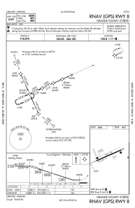
IAC chart of KOMH
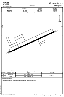
 ADC chart of KOMH
 Satellite view of KOMH
ADC chart of KOMH
Satellite view of KOMH
Sorry, we have no imagery here.
Sorry, we have no imagery here.
Sorry, we have no imagery here.
Sorry, we have no imagery here.
Sorry, we have no imagery here.
Sorry, we have no imagery here.


KOMH - Orange County
Located in Orange, United States
ICAO - OMH, IATA -
Data provided by AirmateGeneral information
Coordinates: N38°14'50" W78°2'44"
Elevation is 464 feet MSL.
Magnetic variation is -09° East View others Airports in Virginia
Operational data
Special qualification required
Current time UTC:
Current local time:
Weather
METAR: KOMH 010435Z AUTO 04003KT 10SM SCT008 BKN048 BKN055 16/16 A2969 RMK AO2
Communications frequencies: [VIEW]
Runways:
| RWY identifier | QFU | Length (ft) | Width (ft) | Surface | LDA (ft) |
| 08 | 66° | 3200 | 75 | ASPH | |
| 26 | 246° | 3200 | 75 | ASPH |
Airport contact information
Address: Orange United States
Satellite view of KOMH
Sorry, we have no imagery here.
Sorry, we have no imagery here.
Sorry, we have no imagery here.
Sorry, we have no imagery here.
Sorry, we have no imagery here.
Sorry, we have no imagery here.