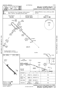
IAC chart of KOKS
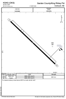
 ADC chart of KOKS
 Satellite view of KOKS
ADC chart of KOKS
Satellite view of KOKS
Sorry, we have no imagery here.
Sorry, we have no imagery here.
Sorry, we have no imagery here.
Sorry, we have no imagery here.
Sorry, we have no imagery here.
Sorry, we have no imagery here.


KOKS - Garden County/King Rhiley Fld
Located in Oshkosh, United States
ICAO - OKS, IATA -
Data provided by AirmateGeneral information
Coordinates: N41°24'7" W102°21'23"
Elevation is 3394 feet MSL.
Magnetic variation is 09° East View others Airports in Nebraska
Operational data
Special qualification required
Current time UTC:
Current local time:
Weather at : KOGA - Searle Fld ( 58 km )
METAR: KOGA 051355Z AUTO 24004KT 10SM CLR M03/M06 A3043 RMK AO2 T10261057
Communications frequencies: [VIEW]
Runways:
| RWY identifier | QFU | Length (ft) | Width (ft) | Surface | LDA (ft) |
| 12 | 134° | 4699 | 60 | CONC | |
| 30 | 314° | 4699 | 60 | CONC |
Airport contact information
Address: Oshkosh United States
Satellite view of KOKS
Sorry, we have no imagery here.
Sorry, we have no imagery here.
Sorry, we have no imagery here.
Sorry, we have no imagery here.
Sorry, we have no imagery here.
Sorry, we have no imagery here.